WILDLIFE MANAGEMENT AREAS
Nevada’s state-owned Wildlife Management Areas (WMAs) are home to many resident and migratory birds and mammals. Found throughout the state, the public can generally drive to a WMA in less than two hours from the major population centers and find great access to wildlife viewing.
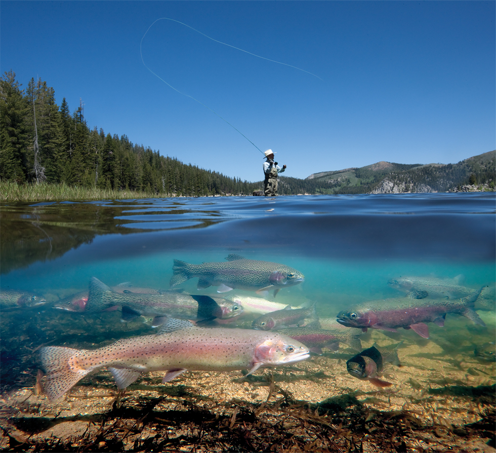
The State of Nevada through the Department of Wildlife owns or has long-term leases on more than 150,000 acres of land incorporated into WMAs across the state. The primary management emphasis on WMAs is the protection of wetlands and waterfowl including the use of the areas as public hunting grounds. Hunting opportunities for sportsmen on WMAs include migratory game bird, upland game bird, furbearer, and big game hunting.
ALKALI LAKE WMA – LYON COUNTY
Alkali Lake Wildlife Management Area (ALWMA) is in Lyon County, Nevada approximately 10 miles southwest of Yerington and approximately 85 miles from Reno. ALWMA consists of approximately 3,561 acres of wetlands and desert rangeland habitat.
Waterfowl species are the most common and abundant wildlife species found on the ALWMA. Management objectives of this property are to maintain waterfowl habitat and provide public recreation. Water availability and changes in return flows has created an intermittent wetland during years of above average snowpack in the Sierras.
| Bodies of Water | Alkali lake |
|---|---|
| Trespass | No restrictions |
| Use of Vessels | No restrictions |
| Use of Campfires | Not Permitted |
| Camping | Not Permitted |
| Hunting | The use or possession of shells for a shotgun containing shot that is toxic or larger than standard-sized T is prohibited. The use of shotguns capable of holding more than three shells is prohibited unless it is plugged with a one-piece filler, incapable of removal without disassembling the gun so its total capacity does not exceed three shells. |
BRUNEAU RIVER WMA – ELKO COUNTY
Located at Nevada’s northeastern border, Bruneau River Wildlife Management Area encompasses some of the state’s most wild and remote landscapes. Hunting and fishing opportunities are abundant, though due to the remote nature of the landscape, always make sure you’re properly prepared before recreating.
| Bodies of Water | Various streams |
|---|---|
| Trespass | No restrictions |
| Use of Vessels | No restrictions |
| Use of Campfires | Permitted |
| Camping | Permitted, however, camping is not permitted in any building or other structure located within the WMA |
| Hunting | The use of shotguns capable of holding more than three shells is prohibited unless it is plugged with a one piece filler, incapable of removal without disassembling the gun so its total capacity does not exceed three shells. |
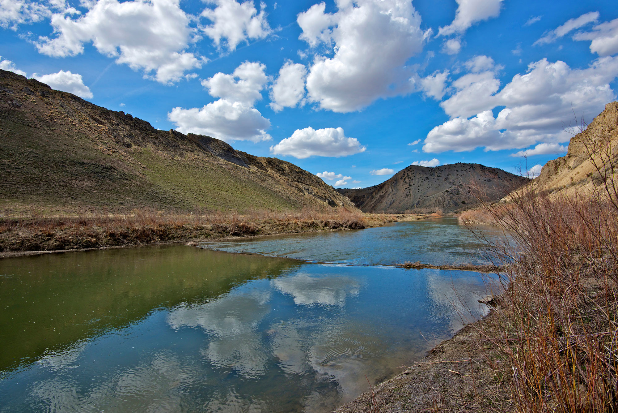
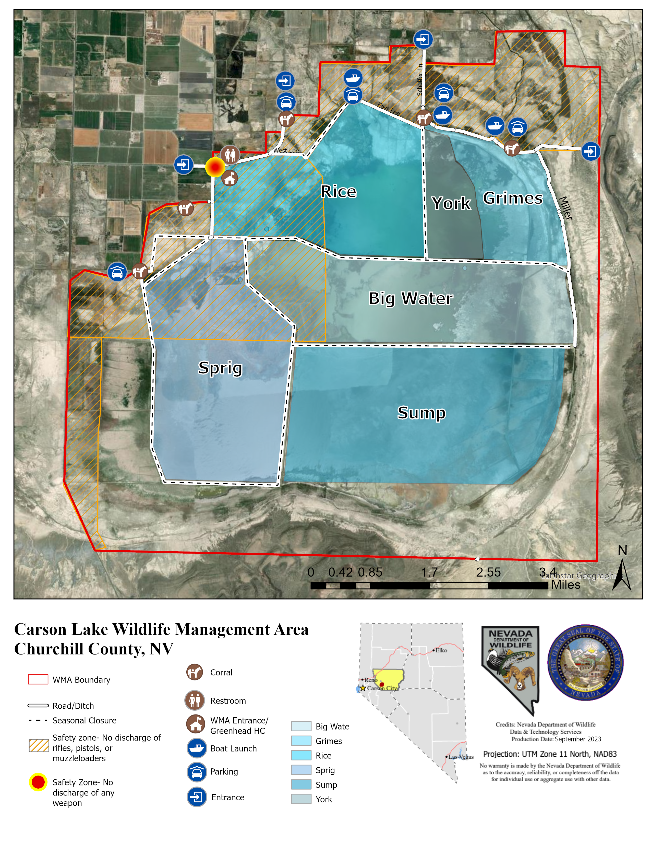
CARSON LAKE WMA
Carson Lake WMA is comprised of 23,040 acres in Churchill County, Nevada and is centered on Carson Lake, which is the natural terminus of the Carson River. Located approximately 8 miles southeast of Fallon, Nevada and 70 miles east of Reno, Nevada. CLWMA and the surrounding basin are remnants of prehistoric Lake Lahontan, which occupied both the Carson Lake and Carson Sink to the north, where Stillwater National Wildlife Refuge is now located. The history of human existence in the Carson Sink dates back more than 7,000 years and includes some of the earliest and most significant archaeological investigations in the Great Basin.
CLWMA currently presents a variety of uses such as hunting, bird watching, and hiking around the vast landscape. Salt flats, upland shrub communities, irrigated pastures, and wetland meadows provide various wildlife species with a wide array of critical habitat. A single road for public access leads into the property, splitting into three dirt roads that are atop levees or adjacent to irrigation canals, circling the pasture and marsh areas. Many of the roads have been graveled to provide all-weather access. Three observation decks for bird watching are available to the public year-round.
| Bodies of Water | Sprig, Big Water, Rice, York, Grimes, Sump unit(s) |
|---|---|
| Trespass | Travel permitted on designated roads only. Travel is not permitted around seasonally closed gates |
| Use of Vessels | Currently no restrictions |
| Use of Campfires | Not permitted |
| Camping | Not permitted |
| Hunting | The use or possession of shells for a shotgun containing shot that is toxic or larger than standard-sized T is prohibited. The use of shotguns capable of holding more than three shells is prohibited unless it is plugged with a one piece filler, incapable of removal without disassembling the gun so its total capacity does not exceed three shells |
FERNLEY WMA – LYON COUNTY
Located just east of Fernley, the Fernley Wildlife Management Area provides wetlands that are important to migratory birds. The area has hiking trails, and can be a great place to spot upland game, along with a plethora of nongame species.
| Bodies of Water | Various intermittent ponds |
|---|---|
| Trespass | No restrictions |
| Use of Vessels | No restrictions |
| Use of Campfires | Permitted |
| Camping | Permitted |
| Hunting | The use or possession of shells for a shotgun containing shot that is toxic or larger than standard-sized T is prohibited. The use of shotguns capable of holding more than three shells is prohibited unless it is plugged with a one piece filler, incapable of removal without disassembling the gun so its total capacity does not exceed three shells |
FORT CHURCHILL COOPERATIVE WMA (MASON VALLEY WMA)
The Cooling Ponds are located adjacent to the North Central portion of the Mason Valley Wildlife Management Area in Lyon County. The Cooling Pond water is used by NV Energy to cool water after it has been used as steam to generate power. Hot water from the power plant is released in the northeast quadrant of the pond, which then flows in a clockwise direction through three other quadrants until it cools for re-entering the power plant. However, since 2009, the power plant has been operated sporadically. The Cooling Ponds offer a roosting site for migrating and wintering waterfowl. NV Energy owns the pond and anglers should respect the property to ensure continued access to the fishery.
| Bodies of Water | Fort Churchill Cooling Pond |
|---|---|
| Trespass | From October 1 through the Friday preceding the second Saturday of February, the area shall be closed to trespass. Fishing allowed from the second Saturday in February through September 30th each year |
| Use of Vessels | No vessels allowed on Fort Churchill Cooling Pond |
| Use of Campfires | Prohibited |
| Camping | Prohibited |
| Hunting | Hunting is prohibited on this area |
FRANKLIN LAKE WMA – ELKO COUNTY
| Bodies of Water | Franklin Lake |
|---|---|
| Trespass | No restrictions |
| Use of Vessels | No restrictions |
| Use of Campfires | Not permitted |
| Camping | Not permitted |
| Hunting | The use or possession of shells for a shotgun containing shot that is toxic or larger than standard-sized T is prohibited. The use of shotguns capable of holding more than three shells is prohibited unless it is plugged with a one piece filler, incapable of removal without disassembling the gun so its total capacity does not exceed three shells |
HUMBOLDT WMA – PERSHING & CHURCHILL COUNTIES
The Humboldt Wildlife Management Area (HWMA), also known as Humboldt-Toulon, is located in Pershing and Churchill counties, Nevada, approximately 10 miles southwest of Lovelock and 80 miles east of Reno/Sparks. The area that comprises the HWMA has a rich history of human activity starting as early as 2,000 B.C. with Native American tribes that occupied cave dwellings in the West Humboldt Range and hunted for wetland associated wildlife within the Humboldt Sink (Sink). In the early 1910s, numerous artifacts were discovered in the cave sites surrounding the Sink including the world’s oldest (at over 2,000 years) known waterfowl decoy made from tules.
During the mid-1850s, emigrants traveling West used the Emigrant Trail which travels along the west side of the Sink. The settlers would stop at what is now the Toy Railroad Siding to stock up on fresh water before beginning their trek across the Forty Mile Desert. In 1953, the Nevada Fish and Game Commission began efforts to create a state managed wildlife area within the Sink. Through a series of leases, purchases, land trades and donations, the HWMA was created and today comprises a total of 36,060 acres of land.
| Bodies of Water | Upper and Lower Humboldt Lakes and Toulon Lake |
|---|---|
| Trespass | No restrictions |
| Use of Vessels | Airboats are prohibited on Upper and Lower Humboldt Lakes until 1 hour after the legal shooting time on the opening day of the waterfowl season. Airboats are prohibited on the Toulon Lake portion of the area during the waterfowl season. All vessels are prohibited on the ponds 5 days before the opening day of the waterfowl season |
| Use of Campfires | Permitted in those sites designated for camping |
| Camping | Permitted at sites designated for camping |
| Hunting | The use or possession of shells for a shotgun containing shot that is toxic or larger than standard-sized T is prohibited. The use of shotguns capable of holding more than three shells is prohibited unless it is plugged with a one piece filler, incapable of removal without disassembling the gun so its total capacity does not exceed three shells |
KEY PITTMAN WMA – LINCOLN COUNTY
Key Pittman Wildlife Management Area (KPWMA) is located in the north end of the Pahranagat Valley between the Pahranagat Range to the west and the Hiko Range to the east. The WMA is approximately 135 miles south of Ely and 110 miles north of Las Vegas on Highway 318.
The Nevada Department of Wildlife (NDOW) currently manages 1,337 acres including Nesbitt and Frenchy Lakes and appropriated water rights totaling approximately 632 acre feet annually from Hiko Springs managed by the Hiko Ditch Company and 580 acre feet annually from Crystal Springs.
| Bodies of Water | Nesbitt and Frenchy Lakes |
|---|---|
| Trespass | Trespass prohibited from Feb. 15 through Aug. 15 in the portion of Nesbitt Lake north of the old fence line |
| Use of Vessels | Vessels must be operated at a speed that leaves a flat wake, but in no case may exceed 5 nautical miles per hour. No motorized boats are allowed on the area during waterfowl season |
| Use of Campfires | Not permitted |
| Camping | Not permitted |
| Hunting | Overton/Key Pittman Reservation System |
- During the waterfowl season, hunting is permitted on the opening weekend of the duck season, odd-numbered days throughout the season, opening day of the goose season, and the closing two days of the waterfowl season.
- The maximum hunter capacity during the opening day of duck season and the opening day of goose season will be 55 at any time.
- All hunters will check-in and out at the main entrance and will park in designated parking areas only. No vehicles are allowed on the area during the hunting season.
- The area is closed to fishing during the waterfowl season. No motorized boats are allowed on the area during waterfowl season.
- Trapping is allowed with valid permit. Permits will be issued through a drawing process and may contain designation of specific trapping areas, dates or other restrictions to ensure compatibility with other public activities.
- The use or possession of shells for a shotgun containing shot that is toxic or larger than standard-sized T is prohibited.
- The use of shotguns capable of holding more than three shells is prohibited unless it is plugged with a one piece filler, incapable of removal without disassembling the gun so its total capacity does not exceed three shells.
MASON VALLEY WMA – LYON COUNTY
The Mason Valley Wildlife Management Area (MVWMA) is located in Mason Valley in Lyon County, about 75 miles southeast of Reno via Interstate 80 and U. S. Alternate 95. The WMA area now totals 17,551 acres.
From desert shrub lands to wet meadows, the habitats of MVWMA support an abundance of fish and wildlife that contribute significantly to the biological diversity of western Nevada. The Walker River floodplain meanders through MVWMA, providing food, cover and water for a vast array of wildlife. Numerous wet meadows and ponds dot the landscape, attracting ducks, geese, swan, songbirds and wading birds. The deep-water habitat of the newly constructed North Pond reservoir is home to fish, osprey and pelicans. Alkali desert scrub, an upland plant community, covers an extensive area on MVWMA and gives shelter to many mammals including raccoon and mule deer.
| Bodies of Water | Note: All fishable waters (listed below) at the Mason Valley WMA are open for fishing beginning the second Saturday of February and ending September 30 of every year (Hinkson Slough, North Pond, Bass Pond, Crappie Pond, Walker River, Numerous other seasonally flooded ponds) |
|---|---|
| Trespass | Trespass prohibited from Feb. 15 through Aug. 15 in the eastern portion of the main developed pond area, as posted |
| Use of Vessels | All vessels are prohibited from Feb. 15 through Aug. 15 each year, except on Hinkson Slough, Bass, Crappie, and North Ponds and the Walker River. Vessels must be operated at a speed that leaves a flat wake, but in no case may exceed 5 nautical miles per hour |
| Use of Campfires | Permitted in those sites designated for camping |
| Camping | Permitted at sites designated by the Department |
| Hunting | During the waterfowl season, hunting is permitted only on Saturdays, Sundays, Wednesdays and the following legal State holidays: Nevada Day, Veterans Day, Thanksgiving, Family Day (day after Thanksgiving), Christmas, New Years Day, and Martin Luther King Day. Hunters with a valid turkey tag for the Mason Valley Wildlife Management Area may hunt each day of the established turkey season. Before or after the waterfowl season, hunting is allowed every day for wildlife species upon which there is an established open season |
Deer may be hunted only with a shotgun no larger than 10 gauge and no smaller than 20 guage using rifled slugs; or shotgun rounds with sabots that contain rifled slugs, or a single expanding projectile, or a bow and arrow. A shotgun that is used to hunt deer may be equipped with a smoothbore barrel or a barrel that is partially or fully rifled. Deer may be hunted only with bow and arrow during the season set for the archery hunt for deer. During the waterfowl season, deer may be hunted only on the following days during the season set for the hunting of deer:
- Saturdays, Sundays and Wednesdays
- Nevada Day as observed
- November 11, Veteran’s Day
- Thanksgiving Day
- Family Day (day after Thanksgiving).
The use or possession of shells for a shotgun containing shot that is toxic or larger than standard-sized T is prohibited.
The use of shotguns capable of holding more than three shells is prohibited unless it is plugged with a one piece filler, incapable of removal without disassembling the gun so its total capacity does not exceed three shells.
OVERTON WMA – CLARK COUNTY
OWMA lies in the lower extremes of the Moapa and Virgin river valleys where they flow into the north end of the Overton Arm of Lake Mead. This is about 65 miles northeast of Las Vegas using Interstate 15 and State Route 169.
Located in the Mojave Desert, OWMA supports an abundance of fish and wildlife that contributes significantly to the biological diversity of southern Nevada. Desert riparian habitat, associated with the floodplain of the Muddy and Virgin rivers, is extremely important to wildlife populations. The dense shrubbery of desert wash habitat provides food and shelter for small mammals and many species of birds. Numerous wet meadows and ponds dot the landscape, providing food, cover, and water for birds, mammals, reptiles, and amphibians. The deep water of Lake Mead provides habitat for fish, cormorants, and diving ducks, while shallow littoral zones provide feeding areas for puddle ducks and shorebirds.
| Bodies of Water | Lake Mead, Honeybee Pond, Center Pond, Numerous other seasonally flooded ponds |
|---|---|
| Trespass | Trespass prohibited from March 1 through Aug. 1 on Honeybee Pond and Center Pond |
| Use of Vessels | Vessels are prohibited on all ponds. Vessels are allowed on the portion of the area inundated by Lake Mead, except that on Overton Hunt Days, vessels may be used only by persons authorized to hunt waterfowl |
| Use of Campfires | Permitted in those sites designated for camping |
| Camping | Permitted in those sites designated for camping |
| Hunting | Overton/Key Pittman Reservation System |
- During the waterfowl season, hunting is permitted on the Moapa Valley portion of the area only on the opening day of the duck season, even numbered days thereafter throughout the season, opening day of the goose season, and the closing two days of the duck and goose seasons. Before or after the waterfowl season, hunting is allowed every day for wildlife species upon which there is an established open season.
- During the opening day and the first weekend of the dove season the maximum capacity for the Moapa Valley portion of the area is 60 hunters by reservation only.
- During the waterfowl season on the Moapa Valley portion of the area, hunters must hunt from assigned hunt locations (blinds) constructed by the Department of Wildlife. A maximum of up to four hunters are permitted at each hunt location. Assigned hunt locations are marked by numbered stakes. Hunters shall hunt only within their assigned hunt location and moving to vacant locations is prohibited. The only exception involves reasonable accommodation of the disabled.
- The hunting of upland game species is prohibited during the waterfowl season.
- On Overton Hunt days, only persons authorized to hunt waterfowl may use vessels on the portion of the area inundated by Lake Mead.
Trapping is allowed with valid permit. Permits will be issued through a drawing process and may contain designation of specific trapping areas, dates or other restrictions to ensure compatibility with other public activities.
The discharging of a rifle or pistol is prohibited.
The use or possession of shells for a shotgun containing shot that is toxic or larger than standard-sized T is prohibited.
The use of shotguns capable of holding more than three shells is prohibited unless it is plugged with a one piece filler, incapable of removal without disassembling the gun so its total capacity does not exceed three shells.
SCRIPPS WMA – WASHOE COUNTY
Scripps Wildlife Management Area (SWMA) is in the southernmost end of Washoe County between Big Washoe and Little Washoe Lakes. Seasonal closures are in place to protect nesting waterfowl and other wetland associated avian species. SWMA was purchased in 1957 to develop and maintain goose nesting habitat and to provide yearlong habitat for waterfowl and other wetlands associated nongame birds. Wet meadow’s, fresh emergent wetlands, and alkali desert scrub are the most prominent habitats found on the 2,351 acre property.
Snowmelt from the Sierra Nevada mountains supplies water to Davis, Franktown, Browns, and Ophir Creeks is the primary water source for SWMA. In high water years pastures can be flooded and in drought years Scripps can remain dry. Given the close proximity to urban surroundings, SWMA is a popular waterfowl and dove hunting location for the Carson City and Reno communities. Other public recreation opportunities on the area include wildlife viewing and hiking.
| Bodies of Water | Washoe Lake |
|---|---|
| Trespass | Trespass prohibited from Feb. 15 through Aug. 15 in that portion of the area that lies south of Little Washoe Lake |
| Use of Vessels | No restrictions except as noted above |
| Use of Campfires | Not permitted |
| Camping | Not permitted |
| Hunting | During the waterfowl season, hunting is permitted seven days a week |
The discharging of a rifle or pistol is prohibited.
The use or possession of shells for a shotgun containing shot that is toxic or larger than standard-sized T is prohibited.
The use of shotguns capable of holding more than three shells is prohibited unless it is plugged with a one piece filler, incapable of removal without disassembling the gun so its total capacity does not exceed three shells.
STEPTOE VALLEY WMA – WHITE PINE COUNTY
The Steptoe Valley Wildlife Management Area (SVWMA) is located immediately south of Ely, along U.S. Highway 93/50 in White Pine County. Comins Lake is located about six miles south of Ely near the ranch headquarters.
The property consists of 12,806 acres including Comins Lake and appropriated water rights of Cave Creek, Steptoe Creek, and Willow Creek. The Bureau of Land Management (BLM) Tamberlaine Grazing Allotment, totaling 27,306 public acres is associated with the WMA
From wet meadows and riparian corridors to sagebrush and pinyon-juniper uplands, the habitats of SVWMA support an abundance of fish and wildlife that contribute significantly to the biological diversity of eastern Nevada. Sagebrush is important habitat for mule deer, pronghorn, sage grouse and a multitude of nongame species. Pinyon-juniper is found on the uplands surrounding the Steptoe Creek drainage. Both pinyon nuts and juniper berries are important food sources for many species of wildlife. The riparian habitats of SVWMA including cottonwood, willow, and aspen have exceptionally high value for many species of wildlife. Ponds and wet meadows dot the landscape of SVWMA, providing food, cover, and water for numerous species of waterfowl, wading birds, and mammals. The deep-water of Comins Lake provides habitat for fish and diving ducks.
| Bodies of Water | Comins Lake |
|---|---|
| Trespass | No restrictions |
| Use of Vessels | Water skiing only allowed between 11 a.m. and sunset. Flat wake restrictions in effect for boats during other hours |
| Use of Campfires | Not permitted |
| Camping | Not permitted |
| Hunting | The use or possession of shells for a shotgun containing shot that is toxic or larger than standard-sized T is prohibited |
Trapping is allowed on a first come, first serve basis and may contain designation of specific trapping areas, dates or other restrictions to ensure compatibility with other public activities.
The use of shotguns capable of holding more than three shells is prohibited unless it is plugged with a one piece filler, incapable of removal without disassembling the gun so its total capacity does not exceed three shells.
WAYNE E. KIRCH WMA – NYE COUNTY
The Wayne E. Kirch WMA is located in the White River Valley in northeastern Nye County. State Route 318 is the major access route to the area. Today, KWMA is composed of a total of 14,815 acres, including five major reservoirs.
From sagebrush to wet meadows and grasslands, the various habitats of KWMA support an abundance of fish and wildlife that contribute significantly to the biological diversity of central Nevada. Wetlands are among the most productive wildlife habitats in Nevada. They provide food, cover, and water for numerous species of birds, mammals, reptiles, and amphibians. Tule, Adams-McGill, Cold Springs, Dacey and Haymeadow reservoirs, developed by NDOW, provide deep water habitat for fish and diving ducks. The edges of the reservoirs provide feeding areas for puddle ducks and shorebirds. The White River bisects the area and provides wetlands and deep water habitats. Uplands on KWMA include sagebrush, alkali desert scrub, annual grassland and desert wash. Sagebrush provides important habitat for mule deer, pronghorn, sage grouse and nongame species. The desert wash habitat is found in narrow corridors around intermittent streams carrying runoff from the Egan Range into the White River Valley.
| Bodies of Water | Dacey Reservoir, Tule Reservoir, Cold Springs Reservoir, Haymeadow Reservoir, Adams-McGill Reservoir |
|---|---|
| Trespass | Trespass prohibited from Feb. 15 through Aug. 15 in the upper portion of Adams-McGill, Cold Springs, Haymeadow and Dacey reservoirs, and all of Tule reservoirs |
| Use of Vessels | Vessels must be operated at a speed that leaves a flat wake, but in no case may exceed 5 nautical miles per hour. Only vessels without motors are allowed on the lower portion of Dacey Reservoir from February 15th through August 15th |
| Use of Campfires | Permitted within the Dave Deacon Campground |
| Camping | Permitted within the Dave Deacon Campground |
| Hunting | Trapping is allowed with valid permit. Permits will be issued through a drawing process and may contain designation of specific trapping areas, dates or other restrictions to ensure compatibility with other public activities |
The use or possession of shells for a shotgun containing shot that is toxic or larger than standard-sized T is prohibited.
The use of shotguns capable of holding more than three shells is prohibited unless it is plugged with a one piece filler, incapable of removal without disassembling the gun so its total capacity does not exceed three shells.